|
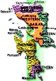
Discover Leyte
LEYTE PROVINCIAL CAPITOL

Location
Cor. Sen. Enage St. & Magsaysay Blvd., Tacloban City
Description
Built in 1907, it is the seat of the provincial government of Leyte.
Attraction
Historic viewing of murals depicting the First Christian Mass in the Orient
and Gen. Douglas MacArthur's landing; became the seat of the Commonwealth
Government of the Philippines when President Sergio Osmeña, Sr. came in 1944
with the WWII Liberation Forces.
CAP BUILDING (formerly
PRICE MANSION)
Location
Justice Romualdez St., Tacloban City
Description
An example of the American colonial home built in 1900.
Attraction
Sturdy mansion where General Douglas MacArthur put up his official
headquarters and residence during the liberation of the Philippines in 1944.
REDOÑA RESIDENCE
Location
T. Claudio St., Tacloban City
Description
Official residence of President Osmeña, Sr. when he came with the Liberation
Forces in October 1944 until the Philippine Commonwealth was reestablished in
Manila.
GEN. DOUGLAS MacARTHUR
LANDING MEMORIAL
Location
Red Beach, Palo, Leyte; can be reached by public transport or private
vehicle.
Facilities
Spacious parking space; garden with a variety of Philippine flowers and
shrubs; beautiful landscaping.
Attraction
Monument marking the spot where General MacArthur landed with the Liberation
Forces; lagoon where the statues of the liberators stand 1.5 times bigger than
lifesize; beautiful beach; Leyte Gulf and Samar Island; 50th Leyte Landing
Anniversary Commemorative Rock Garden of Peace.
HILL 522
Location
Palo, Leyte; 12 kms. from Tacloban City plus trekking 522 ft. up.
Facilities
Clearing site for camporals, picnics and healthful climbing.
Attraction
Commonly called Guinhangdan Hill, it was the entrance to the first liberated
town of Palo in 1944 after having been heavily bombarded to destroy the
garrisons built by the Japanese artillery units; foxholes built by the Japanese
still exist; memorial marker built by Mie Prefecture.
HILL 120
Location
Dulag, Leyte; 34 kms. from Tacloban City.
Facilities
Landscaped garden with tropical flowers and shrubs; benches, concrete tables
with canopy; restroom, open-air stage where memorial programs are held.
Attraction
The hill where the first American flag was raised by the Liberation Forces
of the U.S. Army on October 20, 1944 after the Fall of Bataan; Catmon Hill and
battle sites of Leyte Valley; panoramic view of Leyte Gulf and surrounding
coastal towns.
BUGA-BUGA HILLS
Location
Villaba, Leyte; 125 kms. from Tacloban City.
Attraction
Mountain stronghold of General Suzuki where thousands of Japanese soldiers
died defending the area and hundreds of American lives where sacrificed in the
assault to capture this hill during World War II; frequented by big Japanese
memorial tour groups and bone hunting expedition and object of pilgrimage by
domestic and foreign tourists.
PHILIPPINE-JAPAN PEACE MEMORIAL
Location
Carlota Hills, Ormoc City; 109 kms. from Tacloban City.
Attraction
An impressive memorial marker put up by Nagoya and Gifu Prefectures; one of
the city's picturesque hills overlooking Ormoc Bay.
BOY SCOUT MONUMENT
Location
Rotunda at Fatima Village, Tacloban City.
Attraction
The First Boy Scout monument in the world in human form erected in 1941.
MONUMENT OF THE FILIPINO SOLDIER
Location
Rotunda at Brgy. Pawing, Palo, Leyte.
Attraction
A tribute to the Filipino World War II soldiers and veterans who offered
their supreme sacrifice for the sake of freedom.
PALO METROPOLITAN CATHEDRAL
Location
Palo, Leyte; 12 kms. from Tacloban City.
Attraction
Catholic church; landscaped grounds; gold-plated altar and stations of the
cross carved by local artist.
Description
Converted into an evacuation hospital of the Allied Forces of Liberation and
refuge of civilians during World War II. Founded in 1596 by Augustinian
friars; view of the famous Hill 522 overlooking Palo.
BREAKNECK RIDGE
Location
Brgy. Limon, Capoocan, Leyte; 72 kms. from Tacloban City
Attraction
Site of one of the bloodiest battles during the liberation of the
Philippines; scenic viewing of the battle areas, nearby hills and valleys; now a
busy junction with street vendors, sari-sari stores and eateries serving native
food.
TACLOBAN CITY HALL
Location
Atop Kanhuraw Hill
Facilities
Landscaped garden with concrete tables and chairs; canteen; function hall;
tourism office.
Attraction
Seat of the City Government of Tacloban since June 12, 1952; overview of
Tacloban City, Cancabato Bay, San Pedro Bay, San Juanico Strait, Cataisan Point
and Samar Island; surrounding Philippine-Japan peace memorial markers.
PEOPLE'S CENTER AND LIBRARY
Location
Real Street, Tacloban City.
Facilities
Social hall and reading room.
Attraction
Historical documents recording the rich cultural heritage of the people of
Samar and Leyte; a collection of dioramas of the 82 ethnic tribes of the
Philippines; a collection of books on the humanities.
STO. NIÑO SHRINE AND HERITAGE
MUSEUM
Location
Real Street, Tacloban City.
Attraction
Paintings of the 14 stations of the Cross done by Filipino artists, wooden
bas-relief of the legend of the First Filipino man-woman (Si Malakas at si
Maganda); tastefully decorated guestrooms of varied Filipino motifs; image of
the Holy Child; a collection of original paintings by Fernando Amorsolo;
spacious ballroom; priceless collector's items.
NATIONAL MARITIME POLYTECHNIC
Location
Brgy. Cabalawan, 10 kms. from Tacloban City proper (right at the foot of San
Juanico Bridge).
Facilities
Classrooms; administration building; canteen; dormitories and staff houses;
navigation and maritime engineering laboratories; machine shops; sports and
recreational facilities.
Attraction
Modern shipping technology.
LEYTE STATE UNIVERSITY (formerly
VISAYAS STATE COLLEGE OF AGRICULTURE)
Location
baybay, Leyte; 118 kms. from Tacloban City.
Facilities
Recreational facilities for ground sports, concrete beach kiosks, canteen,
souvenir gift shops, wet market, hostel, guesthouse, pavilion, social hall.
Attraction
Standing on a 1000-hectare campus on the foothills of Baybay mountains,
ViSCA has emerged as premier agricultural college in the south. The
institution has established a reputation in root crop farming; beautiful
landscape; long stretch of beaches for swimming and boat riding; panoramic view
of Camotes Sea; breathtakingly beautiful sunset on summer evenings; museum for
specimen on wildlife.
SAN JUANICO STRAIT
Location
Brgy. Cabalawan, Tacloban City; between the islands of Leyte and Samar - the
south entrance at Tacloban and the north entrance at Babatngon.
Facilities
San Juanico Bridge, motor vehicles.
Attraction
Said to be the narrowest yet most navigable strait in the world.
Beautiful islets and infinite whirlpools; rushing water scene; good for fishing
and water skiing.
RED BEACH
Location
Brgys. Baras and Candahug, Palo, Leyte; 10 kms. from Tacloban City.
Facilities
Beach resort with restaurant, other guest services and sports facilities,
native beach kiosks with wooden picnic tables and benches for rent.
Attraction
Landing site of the Allied Forces headed by Gen. Douglas MacArthur during
the liberation of the Philippines in 1944; panoramic view of Leyte Gulf and
Samar Island; ideal for promenading; picnicking, swimming and windsurfing.
MAHAGNAO NATIONAL PARK
Location
Burauen, Leyte; 66 kms. from Tacloban City plus hiking.
Attraction
Established national park since 1937; awe-inspiring craters, hotsprings,
multi-colored muds and rocks, lakes, virgin forests with giant ferns and
orchids, lagoon, and temperate climate.
TONGONAN HOTSPRINGS NATIONAL
PARK
Location
Ormoc City, 123 kms. from Tacloban (also accessible from Kananga).
Attraction
A valley of geothermal power source that can supply electricity to the whole
region when fully developed; cool and relaxing climate; first geothermal power
plant to operate in the Philippines.
CUATRO ISLAS
Location
Towns of Inopacan and Hindang, Leyte; plus pumpboat ride.
Description
Four lovely isles namely: Digyo, Apid, Mahaba and Himokilan bordered by
white sandy shore; surrounded by beautiful coral gardens, the best in Leyte
Island. A total of 287 species of reef building corals can be found in the
island's waters; rich fishing ground.
MT. PANGASUGAN ECOPARK
Location
Brgy. Pangasugan, Baybay, Leyte
Description
One of the few remaining virgin forests
in the Philippines. It is richly endowed with diverse flora and fauna,
many of which are considered endangered species like flying lemurs and tarsiers;
a unique and precious ecological asset.
MADONNA OF JAPAN
Location
At the foot of Kanhuraw Hill, Tacloban City.
Facilities
Benches, lamp posts, altar for offerings.
Attraction
Landscaped garden with statue of the Goddess of Peace called Maria Kannon
donated by the Japanese people - a symbol of peace and friendship between the
Philippines and Japan; scenic view of Samar Island and Kankabato Bay.
STO. NIÑO CHURCH
Location
Corner Real and Zamora Streets, Tacloban City.
Facilities
Catholic church with daily masses; conference room where religious meetings
are held.
Attraction
Miraculous Image of Santo Niño, patron saint of Leyte; also known as the
Church of Liberation.
STATION OF THE CROSS
Location
On top of the hill above Serin District overlooking Tacloban City.
Facilities
Place for prayer and meditation on the Passion of Christ.
Attraction
The 14 Stations of the Cross in more than life-size concrete forms leading
to the 18-foot statue of the Sacred Heart of Jesus.
SAN JUANICO BRIDGE
Location
Crossing over San Juanico Strait, connects Brgy. Cabalawan, Tacloban City (Leyte
side) and Sta. Rita town (Samar side) approximately 10 minutes from Tacloban
City; accessible by passenger jeepneys, buses, motorcabs and private vehicles.
Attraction
Longest and most beautifully designed bridge in the Philippines; picturesque
San Juanico Strait with a thousand whirlpools; lovely islets; picturesque views.
|